

Leading Innovation in Geospatial IoT Sensing and AI Solutions
The UbiSensing & AI Lab at the University of Calgary develops advanced geospatial sensing and AI solutions that convert distributed ubiquitous data into operational intelligence. With more than a decade of research and deployment experience, we integrate sensor networks, edge computing, cloud native applications, and machine learning into unified decision-support platforms based on international standards.
We engineer systems that do more than monitor — they detect, diagnose, predict, and optimize in real time.
Agentic Geospatial AI Platform
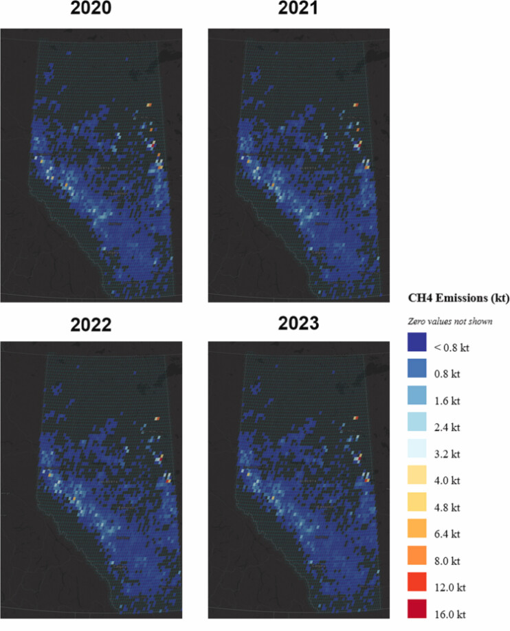
Methane Emission Monitoring
Our methane monitoring framework combines:
- Multi-scale sensing – Integration of ground-based IoT sensors, UAV-mounted detectors, mobile platforms, and satellite data streams.
- AI-driven anomaly detection – Spatiotemporal modeling, plume dispersion simulation, and source attribution using physics-informed machine learning.
- Autonomous tasking – Agent-based workflows that trigger adaptive sampling, drone redeployment, or alert escalation.
- Quantification & reporting – Emission rate estimation using inverse modeling and atmospheric transport models aligned with regulatory standards.
The result is a scalable monitoring infrastructure capable of continuous surveillance, rapid leak detection, and verified emissions accounting across oil & gas, waste management, and agricultural operations.
Smart Agriculture
Our smart agriculture platform integrates:
- In-situ soil and microclimate sensing – Moisture, temperature, salinity, nutrient levels, and canopy conditions.
- Remote sensing fusion – Multispectral and hyperspectral satellite imagery combined with UAV surveys.
- Edge AI analytics – On-site preprocessing for low-latency irrigation and nutrient recommendations.
- Predictive modeling – Yield forecasting, disease risk assessment, and water-use optimization using geospatial deep learning.
- Autonomous decision agents – Dynamic prescription maps for variable-rate irrigation and fertilization systems.
By merging spatial analytics with agronomic models, we enable precision resource management that increases productivity while reducing environmental impact.
Collaboration with Industry and Academia
We partner with industry leaders, public agencies, and research institutions to deploy real-world systems. Our collaborations span pilot testbeds, cross-border sensor networks, and standards-driven interoperability initiatives.
From methane accountability frameworks to climate-resilient agriculture, our work transitions research into operational platforms that deliver measurable outcomes.
Standards, Open-Source, and Community-Driven Innovation
We contribute to open geospatial standards and interoperable IoT architectures that enable seamless integration of community observations, mobile sensing platforms, and real-time analytics pipelines. Our open-source tools support data validation, quality control, provenance tracking, and scalable cloud-edge deployment.
By aligning technical standardization with community engagement, we ensure that heterogeneous sensing systems remain interoperable, transparent, and globally compatible — while empowering stakeholders to actively participate in environmental monitoring, smart agriculture, and climate intelligence initiatives.
Vision
A world where technology helps communities make informed and equitable decisions for a sustainable future.
Mission
To integrate real-world sensor data, geospatial intelligence, and local knowledge into actionable insights that guide better decisions, optimize resource management, and support resilient long-term growth across industries and ecosystems.
Latest posts
Selected publications
- Elementa
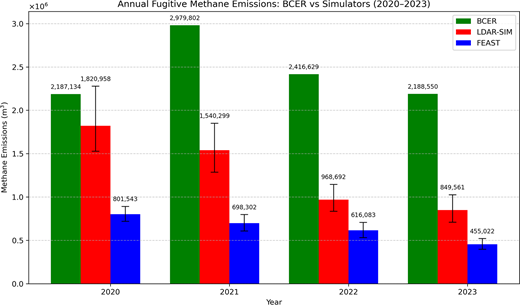 Validating Existing LDAR Simulators Using Real-World Data from British Columbia: A Comparative Study of FEAST and LDAR-SimElementa: Science of the Anthropocene, 2026
 - IJDE
 Enabling a Digital Earth for methane emissions management with equal-area discrete global gridsInternational Journal of Digital Earth, 2025
 - EarthArXiv
 An Event-Based Framework for Estimating Annual Methane Emissions and Managing Emissions Data from Oil and Gas Facilities2025
 - EGU24Toward developing a streamlined workflow for methane emission monitoring, reporting, and verification in the oil and gas industryEGU General Assembly 2024, Apr 2024
- AGU23An ISO/OGC-standard based integrated sensor web architecture for multi-scale methane emissions reconciliationAGU Fall Meeting 2023, Dec 2023
Calgary Centre for Innovative Technologies
University of Calgary
50 Collegiate Place NW
Calgary, Alberta, Canada, T2N 1N4