Current Members
Dr. Steve Liang (梁鴻翎) is a researcher, teacher and entrepreneur. Dr. Liang is currently a professor at the University of Calgary and co-director of the UbiSensing & AI Laboratory. Dr. Liang’s goal is to build a world-wide sensor web, make its information accessible and useful and to empower anyone to build connected applications by using the information generated from the world around them for positive impact at a global scale. For example, Dr. Liang is the editor of the Open Geospatial Consortium SensorThings API and the result of the standard work is to provide a uniform way to expose the full potential of the Internet of Things.
Dr. Liang has been an invited speaker at universities and industries around the world. In 2013, Dr. Liang was chosen one of Calgary’s Top 40 Under 40 by the Avenue Magazine. Dr. Liang held the AITF-Microsoft Industry Research Chair on the Open Sensor Web from 2011 to 2014.
Positions:
- Director of Lab, UbiSensing & AI Research Laboratory
- Professor at the Geomatics Engineering Department, Schulich School of Engineering, University of Calgary
- Founder and CSO, SensorUp Inc.
- Rogers IoT Research Chair, Research Chair
- Chair of WG2, ITU-T FG on Data Processing and Management for IoT and Smart Communitie
- Chair of OGC SensorThings API Standard Working Group
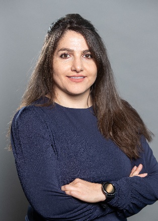
Dr. Sara Saeedi is an Assistant Professor in the Department of Electrical and Software Engineering, the University of Calgary (UofC) and co-director of the UbiSensing & AI research lab. She also serves as an adjunct assistant professor in the Geomatics Engineering Department at UofC. Dr. Saeedi brings extensive expertise in IoT, distributed systems, open geospatial standards, intelligent geo AI, multi-sensor fusion, and integrated navigation systems.
Before joining the University of Calgary, Dr. Saeedi was the Innovation Program Director at the Open Geospatial Consortium (OGC). At OGC, her work encompassed IoT, high-performance distributed computation, smart sensors, and earth observations, collaborating with esteemed organizations such as NASA, ESA, WHO, NRCan, and I-GUIDE. Her commitment to advancing the FAIR (Findable, Accessible, Interoperable, and Reusable) principles of geospatial information through open standards is noteworthy.
Previously, Dr. Saeedi served as the Assistant Director and Post-Doctoral Fellow at the “Geo Sensor Web” Research Lab at UofC. In this role, she made significant contributions to IoT research across the environmental, oil and gas, and health sectors, partnering with CAE Inc., NRCan, Alberta Innovates, and Rogers.
Dr. Saeedi holds a Ph.D. in Geomatics Engineering from the University of Calgary, where her doctoral research focused on multi-sensor positioning, navigation, and wireless location technologies. During her Ph.D., she developed pioneering MEMS-based sensor algorithms for smartphone-based navigation applications. She also earned her Bachelor of Science (B.Sc.) and Master of Science (M.Sc.) from the University of Tehran, where her M.Sc. thesis on vision-aided IMU navigation systems for UAVs was groundbreaking, garnering various awards and leading to her membership in the Iran National Science Foundation (INSF) in 2008. Dr. Saeedi is the editor of the OGC CDB (Common DataBase) standard work to defines a standardized model and structure for a single, “versionable”, virtual representation of the earth. Dr. Saeedi has been an invited speaker at universities and industries around the world on topics related to the IoT, CDB and OGC standards.
Positions and Honors:
- Director of Lab, UbiSensing & AI Research Laboratory
- Assistant Professor at the Electrical and Software Engineering Department, Schulich School of Engineering, University of Calgary
- Adjunct Professor at the Geomatics Engineering Department, Schulich School of Engineering, University of Calgary
Dr. Mingke Erin Li joined the UbiSensing & AI Research Lab in 2024. She earned her Ph.D. in Geomatics Engineering from the University of Calgary, where her doctoral research focused on topographic and hydrological modeling using Hexagonal Discrete Global Grid Systems (DGGS). Supported by Natural Resources Canada and the DOTS (From Earth Observation to Business Intelligence Services) program, her work helped bridge the gap between DGGS methodologies and real-world decision-making applications.
Before joining the UbiSensing & AI Research Lab, Dr. Li gained research experience at the Canada Centre for Mapping and Earth Observation, Natural Resources Canada, and worked as a Geospatial Scientist in the R&D group at Geosapiens Inc. Her research has addressed complex spatial challenges related to natural phenomena, with a focus on developing scalable and practical solutions for environmental and socio-environmental systems. Her long-term vision is to advance a DGGS-powered Digital Earth that enables AI-driven, multi-scale geospatial analysis and supports more informed decision-making across environmental and societal domains .
At the UbiSensing & AI Research Lab, her research focuses on advancing DGGS as a foundation for geospatial intelligence in methane emissions monitoring. She develops spatially explicit methane inventories using equal-area DGGS to enable consistent multi-scale analysis and hotspot detection, and explores the integration of DGGS with multi-agent AI systems for natural language querying, automated data integration, and scalable geospatial reasoning .
For more of Dr. Li’s research blogs and the complete publication list, check her personal webpage.
Mahnoush Mohammadi Jahromi is a dedicated researcher and Ph.D. candidate (2019 - Present) at the UbiSensing & AI Research Lab. She is currently studying the impact of workplace environments on workers’ health by developing an IoT-based system that integrates biometric data with both static and dynamic geospatial contextual workplace information to provide a new approach for workplace fatigue monitoring. By leveraging artificial intelligence (AI) and deep learning algorithms, her work aims to enhance worker safety and well-being through real-time health monitoring and proactive identification of workplace hazards.
Mahnoush holds a B.Sc. in Electrical Engineering from K.N. Toosi University of Technology and an M.Sc. in Biomedical Engineering from the University of Tehran. Before her doctoral studies, she specialized in IoT sensor development, with a focus on hardware design, firmware development and data transfer. At the UbiSensing & AI Lab, she expanded her skill set as a data scientist, gaining expertise in knowledge extraction using AI and DL algorithms, leveraging open geospatial standards, and developing interactive dashboards.
Her academic journey is distinguished by multiple prestigious scholarships, including the Alberta Innovates Scholarship (for 2 consecutive years) and the Alberta Graduate Excellence Scholarship. Beyond academia, Mahnoush is a skilled pianist and a budding violinist, with a passion for hiking and exploring Canada’s natural
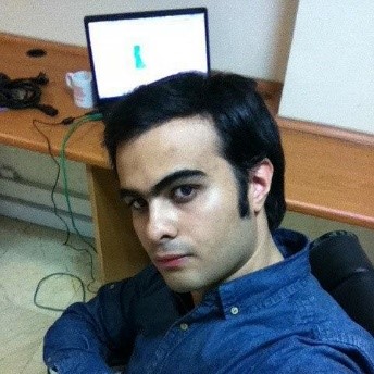
Sina Kiaei is a Ph.D. student (2020 - Present) in the Department of Geomatics Engineering at the University of Calgary, where his academic journey began in 2016 as a master’s student. His doctoral research, titled “A New Approach to Detect and Monitor Methane Emissions in the Oil and Gas Industry: Harnessing Volunteered Geographic Information (VGI),” focuses on utilizing community-sourced data to develop innovative methods for methane detection and environmental sustainability. Supported by prestigious scholarships, including Alberta Innovates and Open Doctoral awards, Sina has built a strong academic record. His research portfolio includes significant contributions to projects like COVID-19 monitoring systems, where he designed cloud-based integration methods to improve system interoperability. Sina has authored and co-authored different papers presented at leading conferences and published in journals. In addition to his research, Sina has actively contributed to the geomatics community through leadership and volunteer roles. He served as Vice President of Treasury for the Geomatics Graduate Student Group (G³) and participated as a judge for the Schulich School of Engineering’s Capstone Design Projects Fair. He is also a dedicated collaborator with the Open Geospatial Consortium (OGC), contributing to the SensorThings API and OGC CDB Standards Working Groups and participating in the OGC Testbed-17 initiative. Sina’s technical expertise has been instrumental in projects like the Boreal Ecosystem Recovery and Assessment (BERA), where he developed a novel 2D web mapping application. Through his research, technical contributions, and leadership, Sina continues to advance geospatial technologies with a focus on environmental and societal impact.
Sina leads an active lifestyle, enjoying skiing in the winter, swimming, running, and regular gym workouts. These activities help him stay fit, focused, and refreshed, providing a healthy balance to his academic and professional commitments.
Positions:
- OGC EmissionML Standards Working Group member
Jin-Ya Wang is a Ph.D. student in Geomatics Engineering at the University of Calgary and a member of the UbiSensing & AI Lab. She received her bachelor’s degree from the Department of Geomatics at National Cheng Kung University, Taiwan, where her undergraduate research focused on satellite image super-resolution using Generative Adversarial Networks (GANs). Her work was supported by the Ministry of Science and Technology (MOST), Taiwan.
Her current research focuses on AI-driven, simulation-based decision support systems for methane mitigation in the oil and gas sector. She develops GeoLLAMA (Geospatial Leak Lifecycle Analysis and Mitigation Agent), a framework that integrates spatial agent-based simulation (built on the GAMA platform) with large language model (LLM)-based planning, execution, and evaluation. Her work enables automated scenario design, simulation orchestration, and policy-aware analysis under real-world constraints such as detection limits, crew logistics, and regulatory compliance.
More broadly, her research aims to generalize methane Leak Detection and Repair (LDAR) systems into a scalable inspection and repair (I&R) framework, incorporating multi-agent systems, spatial-temporal memory, and adaptive planning strategies for complex geospatial operations.
She has published work on validating LDAR simulators using real-world data from British Columbia, highlighting key gaps between modeled and observed mitigation performance.
Positions:
- OGC EmissionML Standards Working Group member
Ali Khalili Tazehkandgheshlagh is a Ph.D. student at the UbiSensing & AI Lab working on AI and smart agriculture. His current research focuses on LEO satellite data integration and AI-driven semantic interoperability for geospatial data. He is specifically contributing to the LEO Gateway project, where he surveys ground stations and IoT sensor networks to build resilient data pipelines.
He holds an M.Sc. in Mechanical Engineering of Biosystems from the University of Tehran (top three in his class), with a strong background in AI, computer vision, the Internet of Things (IoT), and edge computing. His applied experience includes object detection, segmentation, and video action recognition; smart and precision agriculture systems; IoT, embedded systems, and edge computing; and backend and full-stack development with FastAPI, React, and React Native. He has contributed to multiple applied research projects in cattle health monitoring, weed detection, and smart farming systems.
Yasaman is a master’s student in Computer Engineering with a focus on machine learning, real-time data processing, and geospatial analytics. Her background is in software engineering, machine learning, and cybersecurity. She has hands-on experience developing AI-powered solutions for computer vision and real-time event detection, including traffic analysis systems and a machine learning–based fire detection application.
Recently, her first paper, “GICEDCam: A Geospatial Internet of Things Framework for Complex Event Detection in Camera Streams,” was published, presenting a multi-layered IoT framework for spatial and temporal event reasoning in video streams. Her current research interests include agentic AI, real-time computer vision, and conversational AI for geospatial data interaction. She is pursuing this research under the supervision of Dr. Sara Saeedi.
Mohammad Zaid Khan joined the UbiSensing & AI Research Lab in 2026 as an M.Eng. student in Electrical and Computer Engineering at the University of Calgary. He earned his Bachelor’s degree in Computer Science from Saint Mary’s University, completing the program in just 2.5 years.
Zaid specializes in embedded systems and full-stack development, working on everything from low-level firmware programming to scalable web applications. He has built real-world IoT solutions, including a LoRa-based emergency alert network that was deployed across multiple venues, achieving sub-2-second response times and 99.9% reliability. His work connects the physical world of electronics with cloud-based software systems.
His technical background includes developing C/C++ firmware for microcontrollers, building backend systems with Python over Linux, and prototyping hardware using Arduino, Raspberry Pi, and custom circuit designs. Before joining the lab, he worked on automated trading systems serving hundreds of users and designed electrical systems for commercial facilities.
Zaid’s research interests focus on IoT networks, embedded firmware optimization, and creating systems that integrate hardware with scalable backend architectures. He enjoys tackling problems that require both understanding the circuit board and architecting the cloud infrastructure.
Farane Falah joined the UbiSensing & AI Lab in 2025 as a Research Assistant. She earned a Master’s degree in Artificial Intelligence from Tehran, Iran. She is an AI and IoT researcher, focusing on integrating intelligent systems with IoT technologies to solve practical and real-world challenges. Her research interests include hybrid chatbot systems, Retrieval-Augmented Generation (RAG), and developing scalable cloud-native architectures for AI and IoT applications. Farane is particularly interested in combining IoT data streams with AI algorithms to enhance decision-making, efficiency, and human–technology interaction. She is also exploring the application of open geospatial standards and real-time data analytics for smart systems.
Aminreza Abbasi joined the UbiSensing & AI Lab in 2026 as a Research Assistant.
He is an undergraduate Computer Science student at the University of Calgary with a minor in Data Science, working on smart agriculture research over the summer. Aminreza has experience building intelligent monitoring systems for operational environments, and a research background in medical imaging and AI for healthcare, with an emphasis on interpretable models. He has also contributed to agricultural AI, including wheat head detection with computer vision, and to ventures that apply AI and data-driven methods to livestock management and agricultural decision-making.
His interests include computer vision, machine learning, and applications of AI in agriculture and the environment.
Rajdeep Das joins the UbiSensing & AI Lab in 2026 as an NSERC Undergraduate Student Research Award (USRA) summer student, working under the supervision of Dr. Steve Liang.
He is a third-year Software Engineering student at the University of Calgary. He brings strong hands-on experience in full-stack development, AI integration, DevOps (Docker, Kubernetes, CI/CD), and distributed systems, together with a solid foundation in machine learning and data analysis using Python, TensorFlow, and scikit-learn.
More information is available on his personal website.

Kan Luo is a GIS specialist and full-stack engineer. With a background in geospatial technologies, web applications, and the Internet of Things (IoT), he supports the lab’s research, operations, and collaborations. His role includes maintaining technical infrastructure, enabling the smooth integration of advanced tools and methods into the lab’s work, and coordinating projects. By bridging technical expertise with research needs, Kan helps ensure that the lab’s initiatives progress efficiently and effectively.
Kan is currently working closely with Dr. Steve Liang on the development of EmissionML, an emerging open standard for representing and sharing emission data. He is particularly interested in leveraging AI techniques to improve the analysis and interpretation of large-scale spatio-temporal datasets, with the goal of enabling more accurate and actionable insights for emission monitoring. By working closely with researchers, students, and industry partners, Kan fosters collaboration and innovation, helping to build smarter infrastructure, support environmental sustainability, and promote the global adoption of open geospatial standards.
Positions:
- OGC EmissionML Standards Working Group member

NK is a Ph.D. student in the Department of Electrical and Software Engineering at the University of Calgary, working under the supervision of Dr. Sara Saeedi and Dr. Steve Liang. His primary research interests lie in the intersection of GeoAI, cloud-native data platforms, and the integration of machine learning with large-scale geospatial datasets. He is particularly interested in exploring how modern data architectures and advanced analytics can support applications such as environmental monitoring, smart cities, disaster response, and sustainable resource management. By combining distributed computing, geospatial intelligence, and AI-driven methods, NK aims to contribute to the development of interoperable and scalable systems that address critical challenges in geospatial data science.
NK is a data consultant and cloud data architect with over ten years of professional experience in the field of data-intensive systems. His expertise lies in designing and implementing large-scale, cloud-native data infrastructures that integrate advanced analytics, distributed computing, and scalable storage solutions. With a strong background in both theoretical foundations and applied practices, NK brings a unique perspective that bridges academic research and industry application, enabling the development of architectures that are efficient, resilient, and sustainable.
NK’s technical competencies span a broad range of technologies, including cloud platforms (AWS, Azure, GCP), distributed data processing frameworks (Apache Spark, Databricks), and modern data lakehouse ecosystems (Apache Iceberg, Delta Lake, Parquet). His experience also includes real-time streaming systems (Kafka, Kinesis), infrastructure-as-code (Terraform, Kubernetes, Docker), and AI/ML integration for data-driven applications. Through his work, NK has consistently advanced the principles of interoperability, scalability, and performance in data systems, contributing to both the practice and evolving research on cloud-native and geospatial data architectures.
Alumni
Dr. Sepehr Honarparvar completed his Ph.D. (2020 - 2025) in Geomatics Engineering at the University of Calgary. His doctoral research focused on developing advanced frameworks for real-time complex event detection in large-scale video and IoT networks, integrating computer vision, GeoAI, and cloud–edge computing to enable scalable, cost-efficient, and accurate detection of complex spatiotemporal events across distributed camera and sensor systems.
Dr. Honarparvar holds a Master’s degree in GIS and a Bachelor’s degree in Geomatics Engineering, both from K.N. Toosi University of Technology. He has a strong academic and research background, having been awarded the prestigious Alberta Innovates scholarship. His research interests include the Internet of Things (IoT), video processing, deep learning, and cloud-based geospatial data processing and analytics. He has published several papers in the fields of IoT, complex event detection, and volunteered geographic information.
Humaid Kidwai joined the UbiSensing & AI Lab in 2023 as an M.Sc. student in the WE-TRAC specialization stream. He is a budding Researcher and a Software Engineer. He earned his Bachelor’s degree in Computer Science from National Institue of Technology, Jalandhar, India. His work at UbiSensing & AI Lab is focused on Geo-IoT, Big Data and OGC standards. As an M.Sc. student, he is actively involved in the revision of OGC SensorThings API standard, in collaboration with researchers from Europe and America. His work is also supported by Canada Standards Association (CSA) through a competitive scholarship award. Additionally, his dissertation is focused on creating an efficient, scalable and cloud-native architecture for archiving large volumes of Geo-IoT data.
Prior to joining UbiSensing & AI Lab, he worked as a Senior Software Engineer at Samsung Research Institute where he was involved in developing and optimizing 5G core engine using network function virtualization, packet pipeline vectorization and kernel bypass techniques
Dr. Zahra Bagheri-Ashena is a former Postdoctoral Associate at the University of Calgary. At UbiSensing AI Lab, she focused on developing advanced geospatial and AI-driven methodologies to address methane emission reduction and data management. Her expertise encompasses deep learning, large language models (LLMs), computer vision, statistical and numerical modelling and cloud computing. She has a proven track record of applying these techniques to geophysical data analysis, resource modelling, and environmental monitoring.
Dr. Bagheri-Ashena holds dual Ph.D. degrees in Geomatics Engineering from the University of Calgary and Geophysics from the University of Tehran. During her academic journey, she developed new techniques for geophysical data simulation, focusing on multi-source data integration and predictive modelling. Her research involved the application of deep neural networks and inversion techniques to resource modelling.
Recognized as an award-winning researcher, Dr. Bagheri-Ashena was honored for her contributions to AI in Geosciences. Her work demonstrates a commitment to developing impactful technologies that transform complex data into practical solutions.
Dr. Mozhou Gao completed his Ph.D. in 2023 at the University of Calgary’s Centre for Smart Emissions Sensing Technologies (SENST). He holds a Master’s degree in Geographic Information Systems (GIS) from the University of Calgary (2016–2018) and a Bachelor’s degree in Geophysics from the University of Alberta (2011–2016). Dr. Gao’s Ph.D. thesis focused on optimizing, simulating and evaluating the deployment of multi-scale emission measurement systems. During his time at the UbiSensing & AI research lab, Dr. Gao developed methodologies to integrate measurement data with oil and gas operational data under the emission event framework, enabling more accurate emission estimates and uncertainty quantification.