OGC SCIRA Pilot
GeoSensorWeb Lab has contributed to the OGC's (Open Geospatial Consortium) pilot study on Smart City Interoperability Reference Architecture (SCIRA). In this pilot study, we explore interoperability solutions for smart city applications and infrastructure.


Objective
Design and develop a smart traffic/road sensor for real-time monitoring of intersections, counting the number of pedestrians and vehicles, estimating the average speed of the vehicles, and in the case of flash flooding, detecting the level of water, and publishing all extracted data to a SensorThings API-based server.
Description
GeoSensorWeb Lab has contributed to the OGC’s (Open Geospatial Consortium) pilot study on Smart City Interoperability Reference Architecture (SCIRA). In this pilot study, the capabilities of the SCIRA such as its interoperability and standard-based architecture, were demonstrated for public safety in ‘real world’ scenarios. This pilot study was focused on the city of St. Louis, Missouri, to test real-world public safety scenarios.
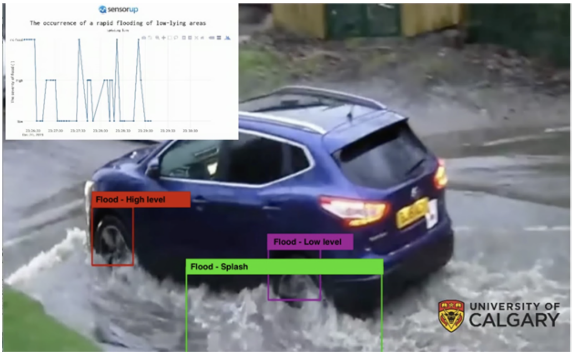
During this pilot, a smart traffic/road sensor was designed and developed to monitor the intersections in real-time and send extracted information to the server. For the flooding scenario, the smart road sensor could detect flash flooding and estimate the water level, count traffic and send the extracted data to the server. This system monitors the number of pedestrians, vehicles, and the average speed of the vehicles. In flash flooding scenario, it detects the existence of water and estimates the level of water. Two different architectures (edge-based and cloud-based) were proposed for this sensor. At the core of the proposed machine learning (ML) algorithms, YOLOv3 (at the time of this study, YOLOv3 was the latest version of YOLO) was used for detecting pedestrians and vehicles, and later, it was trained for detecting standing water on the street and estimating the level of water. Two online demos for each of the model’s capabilities were prepared for this pilot. In the online demos, the real scenario was simulated in the GeoSensorWeb lab at the University of Calgary. Two video files were prepared for this pilot: 1) a highway with vehicles and pedestrians, 2) a flash flooding in the streets. In order to illustrate the real-time performance of the sensor, the camera was pointed to a pre-recorded video file. The developed sensor captures real-time images from monitor I, where the prepared video is displayed, and passes it to the ML model. The results of the ML model were visualized in a screen connected to the Jetson (monitor II), and simultaneously, they were pushed to a SensorThings API endpoint.
Project Details
Sponsor(s): OGC and City of St. Louise Missouri
Collaborator(s): Mahnoush M. Jahromi, Sepehr Honarparvar, Dr. Sara Saeedi
Highlights:
- Online demo of the flash flooding scenario
- Online demo of smart traffic sensor
- Engineering Report
Date: 2019